Topic: Sea Level Rise from Mass Gain and Thermal Expansion
Goal: Study what contributes to global mean sea level rise using satellite measurements.
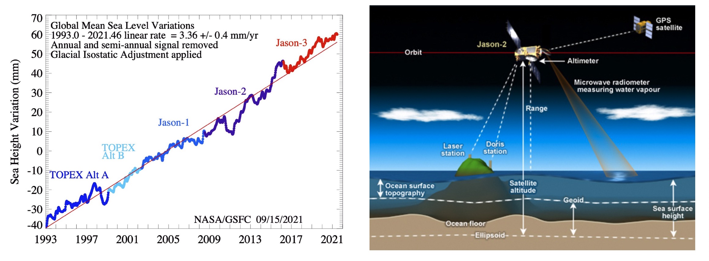
Introduction: Global mean total sea level variations measured by satellite altimeters (TOPEX/Poseidon, Jason-1,2,3) from 1993 to 2021 show a linear rate of 3.36 +/-0.4 mm/yr. The global mean sea level rise is contributed by two main components: (1) eustatic sea level rise and (2) steric sea level rise. The eustatic sea level rise is the expansion of the oceans due to increasing mass, is mostly due to the melting of grounded ice sheets, and can be measured by satellite gravimeters (e.g., GRACE). The steric sea level rise is the expansion of the oceans due to increasing volume, involves both ocean warming and freshening, and can be measured by in-situ conductivity temperature depth profilers (e.g., ARGO, XBT). Disentangling these contributions is very important because it helps us understand ocean heat uptake and project sea level rise.
Datasets:
- MEaSUREs-SSH multi mission altimetry (based on TOPEX/Poseidon, Jason-1.2.3)
- /home/jovyan/shared/NASA_Summer_School_2025/sea_level_rise/materials/data/gmsl/GMSL_TPJAOS_5.1_199209_202203.*
- GRACE water storage (equivalent water height over land and ocean)
- /home/jovyan/shared/NASA_Summer_School_2025/sea_level_rise/materials/data/grace/nasa_grace_*
- NOAA World Ocean Atlas steric sea level products (based on ARGO, XBT, etc)
- /home/jovyan/shared/NASA_Summer_School_2025/sea_level_rise/materials/data/gmsl/noaa_gmssl.nc
Scripts:
- Location: /home/jovyan/shared/NASA_Summer_School_2025/sea_level_rise/materials
- sea_level_rise_v2.ipynb - Main notebook for exercises.
Tools:
Questions:
- Use MEASURES-SSH global mean sea level to calculate the trend and acceleration in global mean sea level. If you project these trends forward, how much will sea level rise by 2100? What might go wrong with this kind of projection? What could it be missing?
- For the overlap period, compare ocean mass increase from GRACE and steric change from NOAA with the total sea level rise from altimetry (the MEASURES product). Do they agree? How well, and what does this imply? Do the mass and steric contributions add up to give the total global mean? Why might they differ?
- Explore the sea level data regionally using the Sea Level Explorer. Consider points along the US East and West Coast. Does sea level rise faster or slower than the global mean? Why might they differ?
Topic Scientist: Josh Willis (joshua.k.willis@jpl.nasa.gov)
Project Server: https://hub.jpl-cmda.org